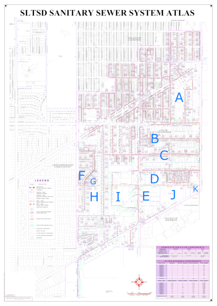
SLTSD Sanitary sewer system atlas
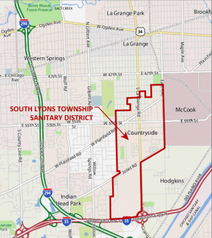
The SLTSD was originally incorporated on August 15, 1959 as the Countryside Sanitary District in order to provide waste water disposal services to the then unincorporated region situated south of the Village of La Grange. In 1961, with widespread public concern over the need for potable water and other public services, the area residents voted to incorporate properties to form the City of Countryside. Following the formation of the City of Countryside, the Countryside Sanitary District subsequently changed its name to the South Lyons Township Sanitary District in order to avoid possible confusion with a the new municipality. The SLTSD encompasses an area of about 1,324 acres, which overlaps the political western Springs jurisdictions of the City of Countryside, the Village of La Grange, and a small portion of unincorporated Cook County. Land use within the SLTSD is largely mixed, with about sixty-two percent (62%) residential, and about thirty-eight percent (38%) commercial/industrial. The land surfaces 5 a N countryside are considered to be fully developed for the current zoned uses. Given the lack of large undeveloped land areas, future development will likely involve the redevelopment of existing land uses. With the current land use characteristics, radical changes in land use are not expected, and only minor changes to sewer use are expected to occur as a result of future redevelopment activities.
The South Lyons Township Sanitary District (SLTSD) is located in west-central Cook County, about 14 miles southwest of the City of Chicago as measured along the Stevenson Expressway (I-55). As shown in Figure 2, the SLTSD is generally bounded by 49th Street on the north, East Avenue on the east, the I-55 Stevenson Expressway on the south, and Brainard Avenue on the west.
The SLTSD was originally incorporated on August 15, 1959 as the Countryside Sanitary District in order to provide waste water disposal services to the then unincorporated region situated south of the Village of La Grange. In 1961, with widespread public concern over the need for potable water and other public services, the area residents voted to incorporate properties to form the City of Countryside. Following the formation of the City of Countryside, the Countryside Sanitary District subsequently changed its name to the South Lyons Township Sanitary District in order to avoid possible confusion with a the new municipality. The SLTSD encompasses an area of about 1,324 acres, which overlaps the political western Springs jurisdictions of the City of Countryside, the Village of La Grange, and a small portion of unincorporated Cook County. Land use within the SLTSD is largely mixed, with about sixty-two percent (62%) residential, and about thirty-eight percent (38%) commercial/industrial. The land surfaces 5 a N countryside are considered to be fully developed for the current zoned uses. Given the lack of large undeveloped land areas, future development will likely involve the redevelopment of existing land uses. With the current land use characteristics, radical changes in land use are not expected, and only minor changes to sewer use are expected to occur as a result of future redevelopment activities.
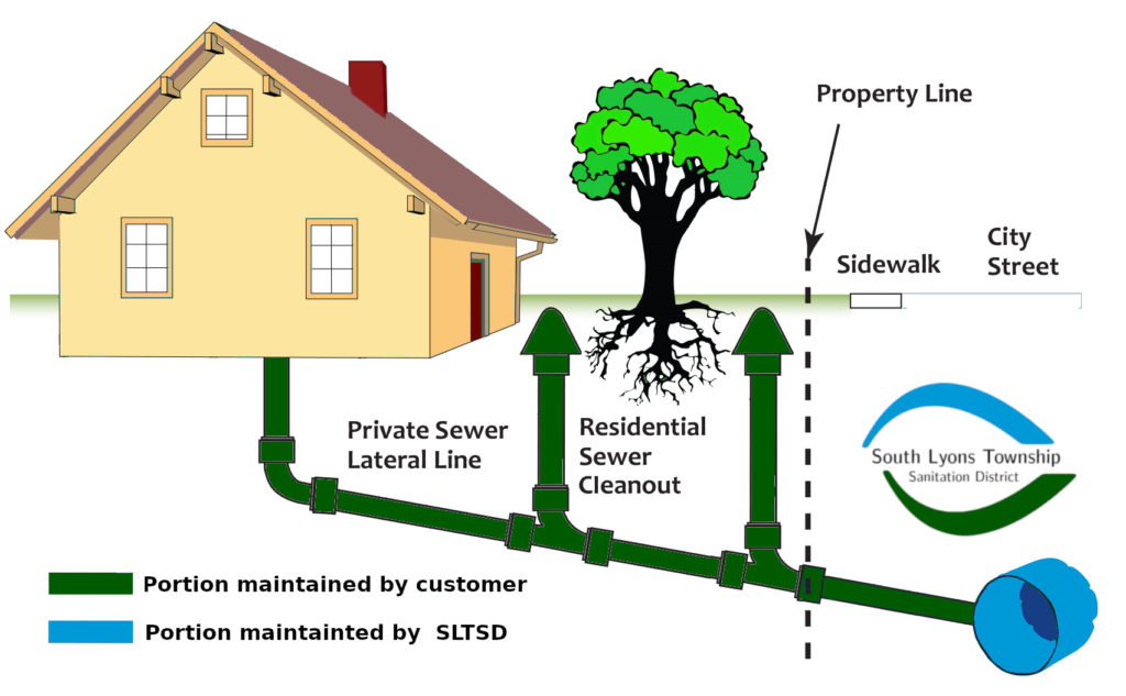
You are responsible for the entire length of your sanitary service lateral from your
building to the main line sewer. Its a good idea to take preventative actions to
reduce the potential for problems. Sewer backups in a home or business may be
caused by a number of factors:
1. A power outage can prevent your sump pump from working. To ensure that
your sump pump continues to operate during a power outage, you could consider
purchasing a backup power supply system which typically maintain power to a
sump pump for an hour or two.
2. Private service laterals can become blocked with tree roots. Roots typically
extend underground as far the tree branches extend from the tree trunk. If your
service lateral is within this area, it is more likely to have tree roots. Avoid putting
large pieces of food and grease in your sinks, dishwashers, and garbage
disposals. Sink strainers are designed to capture pieces of food that should be
thrown in the garbage. Grease can block your lateral. It is best to store grease in
something like an empty soup can. Let the grease solidify before throwing it in the
garbage. Construction near your service lateral can cause movement of nearby
ground and weaken it. If you suspect there’s a blockage in your service lateral, a
plumber can investigate it for you. Some plumbers have the ability to televise your
lateral.
3. Main lines – The District televises the main lines every few years to ensure
they are in sound condition. Heavy rainfall (that’s supposed to go in storm sewers
and creeks) can enter the sanitary sewer from many sources and reduce the
available capacity of the main. If you suspect a main line is blocked, please follow
the guidelines outlined below in the section titled “Do You Suspect There’s a Main
Sewer Problem?”, and contact the appropriate government agency to investigate
the situation.
| Street Name | La Grange | Countryside |
| 6th STREET | 800-1050 E 5222 E | 5324-5416 E 5409-5411 O |
| 7TH STREET | 900-1020 E 901-1025 O 1026-1030 B | 5301-5436 B 5560-5562 E |
| 8TH STREET | 900-1020 E 901-1009 O | 5301-5441 |
| 9TH STREET | 701-845 O | 5235-5440 B 5617-5635 O 5745-5767 B |
| 10TH STREET | 700-861 B | |
| 11TH STREET | 700-850 B | |
| 12TH STREET | 700-870 B | |
| 50TH STREET | 102; 1058; 1201 | |
| 51ST STREET | 1, 5, 7, 9 | |
| 53RD STREET | 11 | |
| 54TH STREET | 5 | |
| 55TH STREET | 450; 475 9570-9590 E 9601-9725 O 9800-9828 E 9901-9945 O 9908-9932 E 10050 | |
| 56TH STREET | 9501-9641 B 9702-9900 E 9807-9901 O | |
| 57TH STREET | 9608 E 9609 O 9620-9726 E 9641-9725 O 9729-9927 B | |
| 58TH STREET | 9601-9645 O 9618-9916 E 9647-9999 O | |
| 61ST STREET | 631; 641; 51; 721 | |
| 61ST PLACE | 630; 64; 650;710; 720;730 E 631; 641; 651; 711 O | |
| ASHLAND | 900-1045 B | 5300-5899 B |
| BARTON | 906-742 B | |
| BRAINARD | 1101-1299 | 5409-6700 |
| CATHERINE | 900-959 B 1001-1099 O | 5300-5899 |
| CONSTANCE LANE | 100-121 B S&W | |
| COUNTRYSIDE PLAZA | Shopping Center | |
| DANSHER ROAD | 5100-5146 B | |
| EAST AVENUE | 700-836 | 5600-5898 |
| FRANCIS AVENUE | 5800-5899 B | |
| JOLIET ROAD | 6140-6298 E 6201-6359 O 6300-6360 E 9600-9800 E | |
| KENSINGTON | 901-945 O 1100-1142 B | 1201 O 5300-6199 B |
| LA GRANGE ROAD | 800-1043 O 900-1040 E | 5221 O 5301 O 5403 O 5410 E 5425 O 5600-6250 B |
| LONGVIEW DRIVE | 700-6099 B | |
| LORRAINE DRIVE | 9700-9799 B | |
| MADISON | 900-1046 B | 5300-5799 B |
| MEADOW | 101-157 B | |
| MEADOWLARK | 100-199 B | |
| MERRY COURT | 1-10 B | |
| PHEASANT | 100-199 B | |
| PLAINFIELD ROAD EAST | 27 O 211-221 O 301-303 O | 44-248 E |
| PLAINFIELD ROAD WEST | 1739 O | 1-399 B 10100-10311 B |
| QUAIL | 100-199 B | |
| ROSE AVENUE | 5800-5899 B | |
| ROSE COURT | 5800-5825 B | |
| ROSEMARY COURT | 5800-5825 B | |
| SPRING | 1100-1299 | 5300-5499 |
| TERRY LANE | 700-799 B | |
| WAIOLA | 1100-1199 |
[/span6][span6]

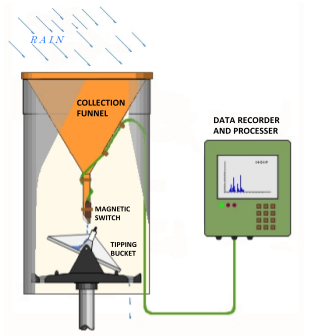
The rain gauge was installed adjacent to the East Avenue and Plainfield Road intersection within the secure fenced area containing the large Village of La Grange water reservoir. This site was selected due to the controlled access, and due to the ideal open space characteristics, which offer the unobstructed collection of rainfall.
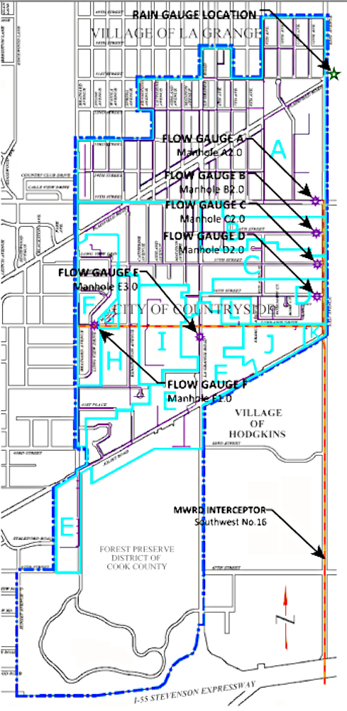
The map exhibit provided depicts the relative positions of the sauging equipment installed for the study. The flow meters were installed in manhole structures located immediately upstream of the connection to the MWRD interceptor manhole. The rain gauge location is also shown relative to the Plainfield Road and East Avenue intersection. The location for each gauging point, defined by an adjacent street address has been listed in Table 10.